Netherlands
M-Scores Stadion
Association football venue · Dordrecht
National park
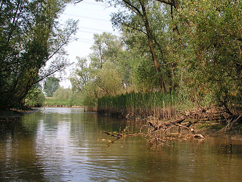
De Biesbosch National Park is one of the largest national parks in the Netherlands and one of the last extensive areas of freshwater tidal wetlands in Northwestern Europe. The Biesbosch ('forest of sedges' or 'rushwoods') consists of a large network of rivers and smaller and larger creeks with islands. The vegetation is mostly willow forests, although wet grasslands and fields of reed are common as well. The Biesbosch is an important wetland area for waterfowl and has a rich flora and fauna. It is especially important for migrating geese.
The Biesbosch National Park consists of the following major parts:
- Sliedrechtse Biesbosch The most northern part of the Biesbosch. This is the part of the Biesbosch with the most significant tidal influence (one of the distinctive characteristics of the Biesbosch). The Sliedrechtse Biesbosch is named after the town of Sliedrecht, which was drowned during the creation of the Biesbosch and was later rebuilt on the other side of the river Beneden Merwede (one of the borders of the Biesbosch). The eastern part of the Sliedrechtse Biesbosch is one of the few areas in the Netherlands that has an intact system of river dunes.
- Hollandse Biesbosch The westernmost part of the Biesbosch and the largest remnant of the (once much larger) South Hollandic part of the Biesbosch. The Hollandse Biesbosch is the part of the National Park best known for its birds.
- Brabantse Biesbosch (Zuidwaard) The eastern and largest part of the Biesbosch, which is separated from the rest of the Biesbosch by the Nieuwe Merwede river (which serves as the borderline between the provinces of South Holland and North Brabant ). The Brabantse Biesbosch can be divided into three parts, from which only the so-called Zuidwaard belongs to the National Park. The Zuidwaard of the Brabantse Biesbosch has fewer fields of reeds and sedges compared to the rest of the National Park and consists mostly of willow forests.

The National Park occupies only half of the original Biesbosch area. The other half has been reclaimed and consists mostly of farmland. It can be divided into several parts as well:
- Dordtse Biesbosch The part of the Biesbosch that borders the city of Dordrecht. It is located between the Sliedrechtse Biesbosch and the Hollandse Biesbosch. Although the Dordtse Biesbosch has largely an agricultural destination, it also contains several recreational areas which serves as the "playground" for the people of Dordrecht.
- Brabantse Biesbosch (Noordwaard) The most central part of the Biesbosch and the subject of much recent controversy. The Noordwaard has only been reclaimed during the 20th century and hosts some of most fertile farmlands in the entire Netherlands. However, as a result of the high water levels in the Dutch rivers during the 1990s, the government has decided to undo the reclamation and reconnect the Noordwaard to the Merwede rivers (essentially the Rhine ). In this way it can serve as a buffer and be of much importance in the prevention of dike breaks and subsequent flooding in densely populated areas in the Rhine-Meuse-Scheldt delta. The first phase of the "de- poldering " has been completed by 2008 and the resulting wetlands have been added to the National Park. The second phase will be completed somewhere between 2015 and 2020.
- Brabantse Biesbosch (Oostwaard) The easternmost and oldest part of the Biesbosch does not resemble the rest of the Biesbosch and consists mainly of farmland and expanded neighbourhoods of towns along the Biesbosch border (such as Werkendam, Nieuwendijk and Hank ), along with a few creek remnants. Much of the Oostwaard has been reclaimed during the 17th and 18th centuries.
The Biesbosch National Park consists of the following major parts:

- Sliedrechtse Biesbosch The most northern part of the Biesbosch. This is the part of the Biesbosch with the most significant tidal influence (one of the distinctive characteristics of the Biesbosch). The Sliedrechtse Biesbosch is named after the town of Sliedrecht, which was drowned during the creation of the Biesbosch and was later rebuilt on the other side of the river Beneden Merwede (one of the borders of the Biesbosch). The eastern part of the Sliedrechtse Biesbosch is one of the few areas in the Netherlands that has an intact system of river dunes.
- Hollandse Biesbosch The westernmost part of the Biesbosch and the largest remnant of the (once much larger) South Hollandic part of the Biesbosch. The Hollandse Biesbosch is the part of the National Park best known for its birds.
- Brabantse Biesbosch (Zuidwaard) The eastern and largest part of the Biesbosch, which is separated from the rest of the Biesbosch by the Nieuwe Merwede river (which serves as the borderline between the provinces of South Holland and North Brabant ). The Brabantse Biesbosch can be divided into three parts, from which only the so-called Zuidwaard belongs to the National Park. The Zuidwaard of the Brabantse Biesbosch has fewer fields of reeds and sedges compared to the rest of the National Park and consists mostly of willow forests.
The National Park occupies only half of the original Biesbosch area. The other half has been reclaimed and consists mostly of farmland. It can be divided into several parts as well:
- Dordtse Biesbosch The part of the Biesbosch that borders the city of Dordrecht. It is located between the Sliedrechtse Biesbosch and the Hollandse Biesbosch. Although the Dordtse Biesbosch has largely an agricultural destination, it also contains several recreational areas which serves as the "playground" for the people of Dordrecht.

- Brabantse Biesbosch (Noordwaard) The most central part of the Biesbosch and the subject of much recent controversy. The Noordwaard has only been reclaimed during the 20th century and hosts some of most fertile farmlands in the entire Netherlands. However, as a result of the high water levels in the Dutch rivers during the 1990s, the government has decided to undo the reclamation and reconnect the Noordwaard to the Merwede rivers (essentially the Rhine ). In this way it can serve as a buffer and be of much importance in the prevention of dike breaks and subsequent flooding in densely populated areas in the Rhine-Meuse-Scheldt delta. The first phase of the "de- poldering " has been completed by 2008 and the resulting wetlands have been added to the National Park. The second phase will be completed somewhere between 2015 and 2020.
- Brabantse Biesbosch (Oostwaard) The easternmost and oldest part of the Biesbosch does not resemble the rest of the Biesbosch and consists mainly of farmland and expanded neighbourhoods of towns along the Biesbosch border (such as Werkendam, Nieuwendijk and Hank ), along with a few creek remnants. Much of the Oostwaard has been reclaimed during the 17th and 18th centuries.
The Biesbosch was created when 300 square kilometres of polder lands were submerged in the St. Elizabeth flood in the year 1421. Before this, the area was called Grote Hollandse Waard, containing cultivated land and a number of villages. The more than a century old dikes collapsed because of lack of maintenance, due to the difficult economic situation in the area, and the difficulties between the political entities within (especially the Hook and Cod (civil) wars ).
One of the key factors in the flooding of the Grote Waard was the creation of a new dike in the southwest of the polder. The ground beneath this dike was unstable, which was a known (but underestimated) fact in this period of time. However, combined with political rivalry and financial issues, this resulted in the creation of an unstable dike, located at one of the key corners of the Grote Waard. It was the only place where high tides coming directly from the sea could penetrate the land deeply and could reach a primary "keystone" dike of the Grote Waard (most of the primary dikes were used as protection against rivers instead).
Very high river levels combined with a severe storm surge coming in from the sea caused the collapse of the southwest dike and several riverdikes, resulting in the flooding of most of the Grote Hollandse Waard. After the flood, three areas remained: the Island of Dordrecht to the west, the Land van Altena (with the city of Woudrichem ) to the east, and the brackish swamps of the Biesbosch in between. Many villages (by tradition 72) were swallowed by the flood and were lost, causing (again by tradition) either 2,000 or 10,000 casualties. Some towns had more luck and submerged, only to rise above the water later on.
Closest places in our Netherlands guide.
More places to explore in Netherlands.