Spain
Cap de Cavalleria Ecomuseum
Ecomuseum · Es Mercadal
Archaeological site
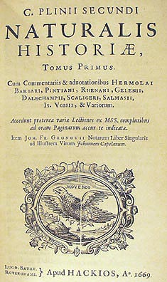
Sanisera was one of the Roman cities located in the island of Menorca (Balearic Islands, Spain), which was mentioned by Pliny the Elder in his book Naturalis Historia, III, 77–78 in the 1st century BC:
The Baleares, so formidable in war with their slingers, have received from the Greeks the name of Gymnasiæ. The larger island is 100 miles in length, and 475 in circumference. It has the following towns; Palma and Pollentia, enjoying the rights of Roman citizens, Cinium and Tucis, with Latin rights; and Bocchorum was a federate town. At thirty miles' distance is the smaller island, 40 miles in length, and 150 in circumference; it contains the states of Jamnon, Sanisera, and Magon.
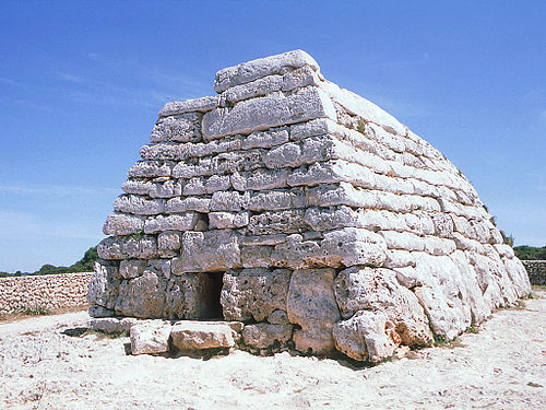
The archaeological site of Sanisera is located in the natural port of Sanitja, next to the Cavalleria Cape or Cap de Cavallería ( Es Mercadal ), which is placed on the rocky northern coast of the island. Cavalleria Cape is a peninsula which points to the north, whose eastern end is called Punta Llevant (eastern point), an 89-metre-high cliff which presents a 19th-century lighthouse; and whose most important inlet is the Port of Sanitja. The western part of the port consists of a long sub-peninsula, whose most characteristic element is an English watchtower built at the beginning of the 19th century, located at its northeastern end. Close to the coast, there are two small rocky islands which act as breakwaters. Regarding the eastern side of the port, it presents similar characteristics to those of the western side, and where S’Almadrava is located, a house which was built in the 18th century as a shelter for fishermen. Moreover, an old quarry of limestone and a lime kiln are located to the south of the port, possibly belonging to the 18th or 19th century. All these elements help the visitor understand the importance of the port of Sanitja, which, despite its small dimensions in comparison to other ports in the island, has always been an inducement of different nature throughout History.
As has already been mentioned, the different structures that can be seen at both sides of the port of Sanitja discern the importance of the place, which is attested by its stratigraphy, since it presents the ideal conditions for the entrance and anchorage of vessels, as well as being a good place for protection in bad weather conditions, such as when the northern wind ( tramontane ) blows. The port, following a south-southeast orientation, is 800 metres in length and c. 150–200 metres in width, and its entrance is flanked by the island of Porros and a rocky arm which measures around 200 metres, belonging to the northern end of the Cavalleria peninsula, being both of them united underwater and in this way creating a natural dike that abates the swell during bad weather conditions. These characteristics have been key factors for many peoples who have settled down in this place; since the Roman army, during the conquest of the Balearic Islands that took place in 123 BC., decided to establish itself in this location as a strategic military enclave. A similar aim was carried out here later on, when the British army, which occupied the island during most of the 18th century, built a watchtower, possibly encouraged by the strategic conditions of the place, something which is also attested by the many bunkers which date from the Spanish Civil War.
Since the area remains undeveloped, archaeological investigations are not limited and will continue revealing more of the rich archaeological potential that Sanitja presents.

The first written source that makes reference to the city of Sanisera is the mention which Pliny the Elder makes in his book " Naturalis Historia" in the 1st century AD. However, later sources have served as clues in order to locate it. One of them consists of the portulan charts from the 16th, 17th and 18th centuries, such as the maps designed by Abraham Ortelius in the year 1590 and Petrus Bertius in 1602; the place name Sanisera appearing in many of them in different ways: Zenage, Porto Senello, Seneua, Seneli, Sa Nitja, Senige, Senitja, Seniya, Seniglles, Senigta, Cenegta, Senoli, Seniga, Seneli, Leneli, Cenega, Senege, Sauia, Sonige, Ceneglia, Zenega, Ianisera, Zenhaga or Zenega.
Apart from cartographical records, with entries for place names that appear in many different maps, it is a very different source which has helped researchers trying to identify the location of the ruins of the ancient Sanisera with the port of Sanitja. Since neither the mention of the city by Pliny nor the maps show or indicate whereabouts exactly in the island of Menorca it was located, the writings of some authors and explorers from the 18th century onwards have been able to shed light on its location. In this way, some writers while describing the area surrounding the port of Sanitja, have pointed out the existence of pottery fragments and other objects scattered on the surface, as well as some structures belonging to old buildings.
Furthermore, there are legends derived from local folklore about the place, such as the legend of "Ses Vilotes" gathered by F.Camps i Mercadal, which mentions the existence of a past population, and the fact that the names Sanisera and Sanitja are similar seems to support this hypothesis. Lastly, its location in a port presenting excellent characteristics makes one think in the logical possibility of a stable human occupation in this spot of the northernmost part of Menorca.
In recent decades, since underwater sports activities started in 1974, a great number of amphorae dating from the 1st to the 4th centuries AD started to be found and recovered from the seabed, thus proving the presence of Roman ruins in this place.
The study of the place name of Sanisera raises some problems, since no analogous forms have been found in the Mediterranean. The work done by J.S. Hernández has shed some light on its origins and composition, without establishing a clear etymological root and possibly ruling out its Latin origin.

The name Sanisera could be made up of two elements: SANI + SERA. The first element, the alleged root Sani-, could be related to the Iberian anthroponim [ check spelling ] sani- as found in many epigraphical records., and, if that would be the case, it would be related to the Iberian language spoken in the Iberian Peninsula. However, we have not found a single analogous term to the suffix –sera in pre-Roman languages. There is a hypothetical explanation, as in the Indoeuropean there exists the root *ser-/*sor-, which means “to run, to flow”. Due to the geographical location of Sanisera, in a natural port in the northern part of the island and close to a stream of fresh water that flows into the sea, the second element could be a geographical reference.
Nevertheless, all this information is hypothetical, since the origins of the name have not been clarified yet. More research should be done in order to find out the etymology of this place name, even though few analogous forms have been found.
During the ‘80s, between the years 1979 and 1984, a series of surveys and excavations which took place at the western side of the port, brought to light the first vestiges of the city of Sanisera: a building with a possible industrial usage, which demonstrate the occupation of the city approximately from the 1st century BC to the 6th century AD; with an alleged period of splendor which lasted until the 3rd century AD.
Also, between 1985 and 1987 the same team located a different building which presented graves both inside and outside its limits. Some years later, it was discovered that the building was an Early Christian basilica (See below for more information on these two buildings).
From the archaeological surveys carried out before excavations started, archaeologists found out that the extension of the Roman city was roughly 60,000 square meters.

Roughly a decade later, from 1993, the study of this site was taken up again with a series of both land and underwater surveys in order to get to know the extension of the archaeology of the port of Sanitja (See below for more information on surveys and excavations carried out from 1993 to the present in the Port of Sanitja).
From that year until the present, the area is under archaeological investigation, having brought to light a Roman military camp which dates from the times of the conquest of the Balearic Islands (123 BC.) to the east of the port, whereas current excavations are focusing on finding the extension, urbanism, function of different spaces and phases of occupation in the city of Sanisera, which is located to the west of the port.
After the excavations carried out during the ‘80s, archaeological investigations were taken up in 1993
Because the site covers a considerable area, it was divided up into plots. A plan was drawn showing all these plots, which were numbered in correlation. In this way, the selected archaeological material from the surface of the terrain would be identified according to these areas
The study of the pottery recovered from the systematic surveys of the area as well as from a private collection shed light on the chronology of the site. The oldest materials are the Punic amphorae, type Maña C and the Punic Ebussitan (PE 14, PE 17). Besides, the most recent materials collected were from North Africa: ARS D type Hayes 105 and amphora Keay LXI, dating from 450-700 AD.
Closest places in our Spain guide.
More places to explore in Spain.