
Italy
Marconi Museum
Museum · Sasso Marconi
Archaeological site

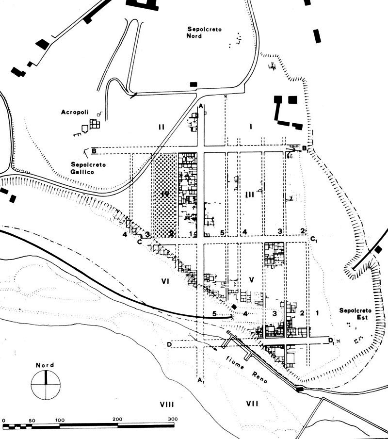
Kainua was an ancient Etruscan city near the modern town of Marzabotto, in the Metropolitan City of Bologna, Emilia-Romagna, northern Italy. It stood on the Pian di Misano and the adjacent height of Misanello, in the valley of the Reno in the Bolognese Apennines. The city developed during the 6th century BC, was reorganized between the late 6th and early 5th century BC, and was abandoned during the 4th century BC, in connection with the Celtic migrations into northern Italy. Kainua is one of the most important archaeological sites for the study of Etruscan urbanism. Unlike many other Etruscan cities, it was not extensively covered by later urban development, allowing streets, houses, workshops, sacred areas, drainage systems, necropoleis and the acropolis to be studied as parts of a single planned city. Historically the site was often known as Misa, a name derived from the local toponym Misano. The ancient name Kainua is inferred from Etruscan inscriptions found at the site, especially the form kainuaϑi, interpreted as a locative expression meaning "at Kainua" or "in Kainua".
The ancient name of the city, Kainua, is inferred from Etruscan inscriptions found at the site. The most important evidence is a cup base bearing the inscription kainuaϑi. The ending -ϑi is interpreted as a locative case ending, indicating a place-name: "at Kainua" or "in Kainua".
Before the identification of the ancient name, the site was commonly known in scholarship as Misa, a modern name derived from Pian di Misano, the plateau on which the city stood. The name Kainua has been interpreted as meaning "the new one" or "the new city". This interpretation is connected with the root kain-, compared with the Greek adjective kainos, meaning "new", and with the planned reorganization or refoundation of the settlement between the late 6th and early 5th century BC.
Kainua occupied the Pian di Misano, a plateau near Marzabotto, and the adjacent hill of Misanello, which functioned as the acropolis. The site lies close to the Reno river, in a position surrounded by hills and supplied by shallow groundwater. These environmental conditions contributed to the choice of the site for settlement.
The city was located along one of the main natural routes across the northern Apennines. The Reno valley connected the Etruscan centres of the Po plain, including Felsina and Spina, with routes leading toward Tyrrhenian Etruria and central Italy. The foundation and development of Kainua are therefore usually understood within the economic and political reorganization of Padanian Etruria during the 6th century BC.
Its position gave the settlement a strategic role between the Po Valley, the Apennine passes and the wider Mediterranean exchange system. The 2023 volume edited by Elisabetta Govi emphasizes the importance of trade routes in connecting Kainua with broader Etruscan and Mediterranean networks.
Archaeological evidence indicates that the plateau was occupied during the 6th century BC. The earliest phase, sometimes identified as the first phase of the settlement, is poorly documented in monumental terms and is represented mainly by scattered groups of materials. These remains show that the area was already in use before the planned city took its final form.
During the second half of the 6th century BC the settlement became more organized. Evidence from domestic buildings, sacred contexts, craft installations and associated finds indicates the development of a community with significant economic and commercial potential.
Between the end of the 6th and the beginning of the 5th century BC the settlement was reorganized according to a planned urban layout. This phase is commonly associated with the name Kainua, interpreted as "the new one", and with a ritual act of foundation or refoundation according to Etruscan religious principles.
The new city plan combined practical urban organization with ritual and cosmological principles. Its regular street grid recalls contemporary experiences of Greek urban planning, but its rigorous orientation according to the cardinal points reflects Etruscan concepts of sacred space and city foundation.

During the 5th century BC Kainua was an important Etruscan centre in the Reno valley. Excavations have revealed residential quarters, sacred buildings, workshops, hydraulic systems and necropoleis. The urban community was part of the wider Etruscan system of northern Italy, which linked the Po Valley, the Adriatic and central Etruria.
The archaeological record shows a city in which domestic life, production, religion and funerary practices were closely integrated. This makes Kainua especially useful for studying the social and economic organization of Etruscan urban communities.
The end of the Etruscan city is associated with the Celtic migrations into northern Italy in the 4th century BC. According to the University of Bologna, the city was abandoned during the 4th century BC because of the Celtic migration. The Kainua Project describes the Celtic occupation as causing the loss of the city's urban identity, with the area assuming the character of a military outpost.
Later Roman occupation did not create a new city on the site. With the Romanization of the area, the traditional trans-Apennine routes were partly replaced by easier routes further east, including the route later known as the Via Flaminia minor. The area of the former Etruscan city was marginal to the main road system and was occupied only by a small Roman rural villa near the ancient settlement.
The absence of major later urban development was decisive for the preservation of the Etruscan city plan. The Italian Ministry of Culture describes Kainua as a unique case among Etruscan inhabited centres because abandonment preserved the original layout of the city.

Archaeological evidence indicates that the plateau was occupied during the 6th century BC. The earliest phase, sometimes identified as the first phase of the settlement, is poorly documented in monumental terms and is represented mainly by scattered groups of materials. These remains show that the area was already in use before the planned city took its final form.
During the second half of the 6th century BC the settlement became more organized. Evidence from domestic buildings, sacred contexts, craft installations and associated finds indicates the development of a community with significant economic and commercial potential.
Between the end of the 6th and the beginning of the 5th century BC the settlement was reorganized according to a planned urban layout. This phase is commonly associated with the name Kainua, interpreted as "the new one", and with a ritual act of foundation or refoundation according to Etruscan religious principles.
The new city plan combined practical urban organization with ritual and cosmological principles. Its regular street grid recalls contemporary experiences of Greek urban planning, but its rigorous orientation according to the cardinal points reflects Etruscan concepts of sacred space and city foundation.
During the 5th century BC Kainua was an important Etruscan centre in the Reno valley. Excavations have revealed residential quarters, sacred buildings, workshops, hydraulic systems and necropoleis. The urban community was part of the wider Etruscan system of northern Italy, which linked the Po Valley, the Adriatic and central Etruria.
Closest places in our Italy guide.
More places to explore in Italy.


