
Australia
Denison Bridge
Truss bridge · New South Wales
Church building

Holy Trinity Anglican Church is a heritage-listed Anglican church precinct, containing the church, rectory and adjacent cemetery, at 71-85 Gilmour Street, Kelso, Bathurst Region, New South Wales, Australia. The church was built from 1833 to 1878, with John Foster being responsible for the building of the original church. Edmund Blacket designed the rectory. The property is owned by Anglican Property Trust Diocese of Bathurst and Parish of Kelso, Anglican Diocese of Bathurst. It was added to the New South Wales State Heritage Register on 14 January 2011.
Dating from 1835, Holy Trinity Church Kelso was the first church consecrated west of the Blue Mountains. With its pioneer cemetery and rectory designed by Edmund Blacket, it is one of the most significant building groups in the Central West region. Holy Trinity played a vital part in the regional growth of the Anglican Church, enjoying the early support of well known religious figures at the time such as Rev. Samuel Marsden and Bishop William Broughton. Although the buildings are not physically located central to village life, Holy Trinity and its parishioners have played an important supporting role in the spiritual growth of the region. The buildings remain in their original use and are much loved and appreciated by the community.
The Bathurst Plains are part of the ancestral homelands of the Wiradjuri people. Their lands were nestled between three rivers; Wambool ( Macquarie ), Kalare ( Lachlan ) and Murrumbidgeri ( Murrumbigee ). These rivers provided a good source of fish, duck, kangaroo, emu and various edible plants. The Wiradjuri had a typical Aboriginal social system based on kinship and totemic lore. The Wiradjuri people resisted European expansion into their territory as it was ruining traditional hunting grounds and desecrating sacred places. Settlement following Governor Macquarie 's first visit to Bathurst in 1815 saw increasing conflict in the region, particularly under the leadership of Windradyne ( c. 1790 - c. 1835 ) and martial law was declared in the Bathurst area for a short time in 1824. The eventual surrender of Windradyne signalled a reduction in hostilities, although the decline in traditional indigenous ways of life continued.
The settlement of Kelso was a direct result of Governor Lachlan Macquarie's opening of a route for colonial settlement in New South Wales west of the Blue Mountains. In 1813 George William Evans extended beyond Gregory Blaxland, William Charles Wentworth and William Lawson 's route over the Blue Mountains into the Bathurst Plains, as they became known, and reported that his exploration found good country. This encouraged Governor Macquarie to arrange for William Cox to take a team of convicts and build a road through the mountains. The road was completed in January 1815, terminating on the left bank of the Macquarie River. On this site on 7 May 1815 Governor Macquarie proclaimed the site of the future town of Bathurst, named after Lord Bathurst, Secretary of State for War and Colonies. Then everyone went to the Governor 's tent for a church service, the first to be held west of the Blue Mountains. However, Macquarie had ordered that no major buildings were to be erected on the (left) Bathurst side of the river until the land was properly surveyed. An alternative to Cox's route to Bathurst was soon available, possibly by the middle of 1815. Being shorter and more direct it quickly established itself as the main route to Sydney from Bathurst. This road approached the Bathurst locality from the right bank – in the area that would develop into the village of Kelso. In 1816 Macquarie granted 50 acres of land each to ten prospective settlers on the right bank. These Kelso settlers pioneered civil community life in Bathurst.
In the muster of 1821 the Bathurst district population was 287 of which 210 were convicts. In 1822 Rev Samuel Marsden wrote to the new Governor Brisbane requesting that grounds be reserved for an Anglican Glebe, school and cemetery. By the mid-1820s the first entries in the Trinity Church registers were made for burials, baptisms and marriages. In 1826 the restrictions to building on the left bank were lifted and the plans for township of Bathurst were drafted. Also a general resurvey of NSW had been ordered in the early 1820s, resulting in a system of counties, townships and civil parishes. The title deed for the James Blackman grant dated 1823, on which the Holy Trinity group would later be built, notes that the land is within the County of Roxburgh and Township of Kelso. This may be the earliest known date mentioning the name of Kelso. Governor Brisbane took over from Macquarie in December 1821 and his wife, Lady Anna Brisbane was born in Roxburgh County, Scotland, near the town Kelso. It is assumed that use of the names Roxburgh and Kelso in NSW was a compliment to her and her home. The Macquarie River posed a major obstacle for many years and divided Kelso from Bathurst. The river was wider and deeper than it is today and suggestions were put forward by the 1820s for a bridge, however in the 1830s the local population were still relying a flat bottomed boat to cross the river.

The survey of the township of Bathurst and subsequent land sales in 1833 led to slow growth of the town and surrounding areas including Kelso. The first bridge across the Macquarie River, finally linking left and right bank settlements, was built of timber in 1855 but was washed away in floods in 1867. It was not rebuilt until 1870, and then in iron and located upstream and away from Church Lane. This led to the gradual bi-passing of the early urban area of Kelso. A new Church of England Parish of Bathurst was established in 1840 and the original parish became the Parish of Kelso. By the mid nineteenth century Kelso's centre had shifted to the crossroads that had developed on the Sydney Road and it was there that the general stores, butchers, coach makers, blacksmiths and other commercial enterprises established their businesses to service the needs of the neighbourhood and travellers. The discovery of gold in the early 1850s had the resultant increase in travellers and supply needs for the region buoyed the local economy and its businesses as elsewhere in the Central West.
The Raglan-Kelso section of the railway was completed in 1875 and Kelso for a period was the important railhead. However the main workshops and engineering yards were located in Bathurst when that section was completed in 1876, despite much lobbying from Kelso councillors. From 1870 to 1910, the effect of the railways making lands further west more accessible eroded the primacy of the Bathurst region. During the early twentieth century Kelso retained much of its village character while maintaining economic growth through its role as a junction on the Sydney Road. Its importance was reinforced in 1908 with the creation of Turon Shire with its Council offices centred in Kelso. The Great Western Highway brought economic development to the village and many businesses catered for the passing trade with garages, workshops and early petrol stations. The river and its unpredictable course gave Kelso a strategic advantage over Bathurst in terms of access and communications during times of flooding.
Abercrombie Shire and Turon Shire amalgamated in 1976 to form Evans Shire Council which retained its head office in Lee Street Kelso. However, when Evans was amalgamated into Bathurst Regional Council in 2004, the shire offices in Kelso were finally closed in favour of the larger offices in Bathurst. Nonetheless, the Sydney Road with its strip development has remained a vibrant area of economic activity in Kelso. Recent years also have seen a dramatic increase in residential land subdivision and creation of new housing estates east of Gilmour Street and to the north of Holy Trinity Church. The growth of Bathurst and resultant increase in land prices has made Kelso a more attractive investment for lower cost residential or retirement villages. The river flats to the west of the Church have not developed due to their flood prone nature and the Church has retained views of the city of Bathurst that have changed little over the years.
The publication "Village of Kelso", researched and written by Carol Churches and Alan McRae, contains useful material on Kelso village life and its growth, including details on commercial establishments and their owners in Kelso.
Archdeacon Thomas Hobbes Scott came to Australia in 1825 as the Archdeacon of New South Wales. He was based in Sydney and his archdeaconry included much of continental Australia, Van Diemen's Land and New Zealand. In New South Wales he had eleven chaplains to care for the religious needs of the community of 35,000, of which the greater part comprised people with a criminal background. In May 1825 twelve new parishes were approved. Eleven of these parishes were planned for the Cumberland Plain and [in addition] "a moderate church at Bathurst" was approved.' Reverend John Espy Keane was appointed to the ecclesiastic parish of Bathurst and he gave the first of many services in Kelso on 22 January 1826 in settler George Cheshire's barn, which also ended up being used as a school during the week. For some time this parish was the only denomination in the region with a resident priest. Other denominations depended upon the visits of itinerant ministers who came to the region from time to time.
Also in the mid-1820s an area of 17 hectares (42 acres) was purchased from original grantee James Blackman for the Church of England Glebe, on the right bank of the Macquarie River. Predominantly open paddocks, it is thought that Blackman had established a small working farm and the church inherited its improvements. By the 1830s the property included a parsonage, barn, stables and other functional outbuildings. The property is likely to have included some livestock including some sheep, cattle and horses. Holy Trinity Church would be built on Portion 82A at the north-western edge of the Glebe with a cemetery adjacent.
In 1832 the new Governor Bourke agreed to fund half the cost of building an Anglican church for the Bathurst parish, with Kelso being the favoured location because it already had land, parsonage and cemetery. After local fundraising efforts to raise the other half of the cost, a contract to build the church was signed on 26 August 1833 by Mr TF Hawkins, Chair of the Church Committee and Mr John Foster, builder. The Reverend Broughton travelled to Bathurst for the laying of the foundation stone, which took place on 1 February 1834. The final cost of the church was A£ 1,128 and it was completed a week ahead of schedule on 19 April 1835. The Senior Chaplain Rev. Samuel Marsden dedicated the church on Easter Day 1835. The Sydney Morning Herald reported that every family within 20 miles was represented at the service. Finally, newly consecrated as Bishop of Australia, Bishop Broughton came to Kelso to consecrate Holy Trinity Church on 3 December 1836. Broughton was the only one to hold the title of Bishop of Australia before it was split into various smaller bishoprics.
The significance of Holy Trinity to the settlement is suggested by its marking as "church" in Thomas Mitchell 's defining survey of Nineteen Counties in New South Wales, drafted around 1830 and published in London in 1834. At the time of the survey the church was yet to be built, but the government apparently attached symbolism to its presence in the newly opened districts of New South Wales. More than simply suggesting the presence of a building, it implies that a society or community is being established here.
At the dedication in Easter 1835, The Sydney Morning Herald described the church as extremely plain but neat, substantial and commodious. Charles Darwin, visiting Bathurst soon after the church was finished, noted, "There is a hideous little red brick Church standing by itself on a hill". When the church was nine years old, a Sydney reporter covering events in Bathurst wrote, "the adjoining town of Kelso possesses a very neat church". Outside there were no buttresses and the tower only reached the ridge of the roof... The roof was of wooden shingles. Inside there were pilasters against the walls that gave the appearance of supporting the flat ceiling. There were four windows in the side walls, as now, however all were paned with plain glass. There were two small windows in the east wall and two small windows on either side of the tower. All the furniture was made of cedar. The box pews had a door at the aisle and parishioners rented a pew, although those not able to meet the rent were allocated a pew at the back. The renting of pews continued until 1921.
The church purchased nearly 73 hectares (180 acres) in 1828. It continued to own nearly 20 hectares (49 acres) for more than 80 years, reduced to seven hectares (seventeen acres) in 1929. In 1997 the old parish hall and land were sold, leaving around six hectares (fifteen acres) in church ownership. In conjunction with the centenary of the parish in 1925 a set of memorial gates were erected at the entrance. After World War II the gravel roads from the street were widened, sealed, curbed and car park built. Dedicated in 1966 the project was named War Memorial Drive to commemorate men and women from the parish who served during World War II.

There have been many alterations and additions to the church since it was first completed. The first major alteration was the replacement of roofing shingles with galvanised iron tiles. In 1875 the height of the tower was increased to conform with the original builder's intentions. This may have been inspired by the offer of a bell in 1874, the first recorded memorial gift, given by Mrs Marian Faviel in memory of her husband Mark. In 1881 the church was able to dispense with candles and oil lamps when gas lighting was installed. In 1889 major works included: raising of the chancel and sanctuary floors and laying of encaustic tiles there; the communion rail was installed; the original box pews were replaced with the present oak pews; the flat chancel ceiling was replaced with the raised, carved lining to the roof; the stained glass windows in the east wall were removed and installed in two of the windows in the side wall; the empty window openings were bricked in and the large, three light window was built into the centre of the east wall; the pilasters were removed and a new stone pulpit, made in England, installed; on the exterior, the walls were buttressed. Edmund Blacket, who was designing the rectory in the mid-1870s, may have been the one who proposed removing the ceiling of the church to expose the timber roof, described as a "visionary" architectural improvement.
In the 1890s further works saw the organ being moved from the gallery and installed in the chancel while acetylene lights replaced gas fittings. Edward Burne-Jones, one of the leading stained glass artists of the late nineteenth century designed the stained glass window which was installed in the east wall using glass manufactured in London. Across the rear of the nave the decorative screen created a baptistery and vestry. By 1910 the rood screen had been erected and the present altar installed and enhanced with a reredos. Some years later the reredos was augmented with panelling across the east wall and the remaining two windows in the side walls filled with stained glass, a memorial to the men from the parish who'd given their lives in World War I. Electricity was connected in 1928. The vestries are more recent additions. Just before World War II the present roof of asbestos cement tiles was installed. During that war all the stained glass windows were removed for safekeeping.
The clergyman originally depended upon parishioners who could sing and lead the psalmody until a barrel organ with just twelve tunes was installed in Holy Trinity in 1841. This was the first musical instrument of any size to cross the Blue Mountains. In 1863 the barrel organ was converted into a keyboard instrument, allowing for other hymns to be played upon it. In the mid-1880s a new organ was installed, built by A. Hunter & Sons of London. One of just ten Hunter organs built for churches in NSW, it is notable in that it remains largely unaltered. Another organ built in 1890 by Telford and Telford of Dublin existed in the Sunday School until 1935 when it was moved to St. Albans, Epping. Now greatly enlarged, this Telford organ serves St. Mark's, Granville.
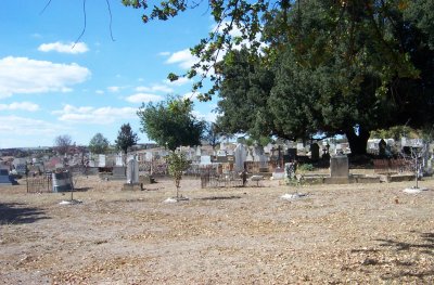
Holy Trinity features a burial ground backing on to the church. Indeed, the first burials took place nine years before the church was built. The earliest section of the cemetery is known as the Pioneer Cemetery. The Rose Garden there was planted in 1939 and became used for cremations in 1960. In 2008 Carol Churches published "Pioneer Cemetery", a register of 95 identifiable graves and vaults containing the remains of 240 early settlers.
Kelso Parish registers were commenced in 1826. From 1856 the Government of New South Wales made the recording of such information a legal requirement and the responsibility of civil authorities. In 1960 the registers were microfilmed by the Mitchell Library and more recently all entries have been transcribed and digitalised.
Closest places in our Australia guide.
More places to explore in Australia.


.jpg?width=1200)
.jpg?width=1200)
.jpg?width=1200)


