_(2011).jpg?width=1200)
Australia
CSR Refinery, New Farm
Historic site · Queensland
Park

New Farm Park is a heritage-listed riverfront public park at 137 Sydney Street, New Farm, City of Brisbane, Queensland, Australia. It was designed by Albert Herbert Foster and built from 1914 to 1950 by Gladwin Legge & Co. It was added to the Queensland Heritage Register on 7 February 2005. The park covers 15 hectares (37 acres) and is at the southeastern end of the New Farm peninsula on a bend in the Brisbane River. The Powerhouse arts centre is at the eastern end of the park. The park includes the New Farm Park ferry wharf and links to the Brisbane Riverwalk from Newstead to Toowong. It is one of Brisbane's most popular parklands and tourist attractions.
New Farm Park, created in 1914, currently covers 15.0076 hectares (37.085 acres) of land, and is bounded by Brunswick Street and Sydney Street, New Farm. It adjoins the Brisbane Powerhouse arts precinct and the Brisbane River.
Prior to European settlement, the New Farm area was covered with bush and dotted with shallow lagoons. It supported a variety of wildlife and proved a bountiful resource to local Aborigines. The area was called Binkin-ba meaning place of the land tortoise.
Following the founding of the Moreton Bay convict settlement on the Brisbane River, the land on which the park now stands was initially a farm. A racecourse was built on the site in 1846, which operated until 1913, when the land for the park was acquired by the Brisbane City Council. The Queensland Governor Hamilton Goold-Adams conducted the official opening of the park, which was delayed until July 1919 because of World War I.
After a penal settlement was founded in 1825 at the location of the current Brisbane central business district, food was grown on cleared land in South Brisbane and the present City Botanical Gardens. In 1827 Captain Patrick Logan ordered the clearing of a new farm between the present day Merthyr Road and the river; drainage canals were dug, and convict labourers grew maize, potatoes, pumpkin, and corn. The convicts were marched to work each day from their main barracks in town, following a track on high ground that later became Moray Street. Due to the decline of the penal settlement following changes in British policy, free settlement began in Brisbane in 1842. A farmer named Prendegast appears to have planted maize at the new farm in 1842, although he was only leasing the land.
Speculators in 1844 purchased the new farm's lowlands, and tenant farming followed, with dairying and small crops. Early resident Richard Jones acquired 93 acres (38 ha) in 1847, and called it "New Farm". Later Jones would become the first Brisbane person to be a Member in the New South Wales Legislative Council (prior to the separation of Queensland in 1859).
In 1846 the Moreton Bay Jockey Club moved its annual race from Coopers Plains to land at New Farm owned by Thomas Adams. This land included Eastern Suburban Allotments 22, 28, 29 and 30, located at the south-eastern corner of the New Farm peninsula. The first (members only) meeting was held in May 1846, and public attendance began at the 1848 three-day race meeting. By 1849 the "Brisbane Races" were being held over the Christmas-New Year's period. The race meetings moved to Eagle Farm in 1861.
Opinions vary as to the exact location of the racetrack itself. During the 1880s the land once owned by Thomas Adams was marketed for subdivision as the "Old Racecourse Estate", but allotments 28 to 30 included both the site of New Farm Park, as well as the land to the north of the small creek that formed the park's north-eastern boundary. In 1895, Merthyr Road was known as "Old Racecourse Road", and in 1913 the annual report of Henry Moore referred to the "old racecourse paddock" that was to become "New Farm Park". A 1925 aerial photo ( John Oxley Library ) appears to show the remains of the track on the site of the Colonial Sugar Refining Company Refinery and the site of the Powerhouse, intersected by Lamington Street near the river.
As horse racing disappeared from the area, suburban Brisbane was growing. The Municipality of Brisbane was formed in 1859, and the small farms of New Farm gave way in the 1870s to the residences of Brisbane's elite. Sir Samuel Griffith purchased 80 acres (32 ha) bounded by Sydney Street and Moray Street in 1870, and built his residence "Merthyr" in 1881 (demolished 1963).
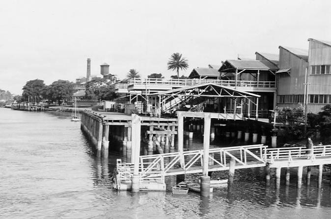
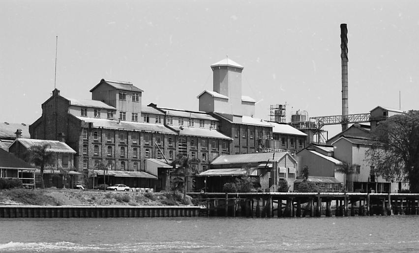
Low-density residential development was also occurring in James Street, Brunswick Street, and Bowen Terrace by 1879. In 1884, suburban development was mainly contained within the Moray Street, Merthyr Road, and James Street area. Many estates were subdivided during the 1880s speculative boom, but they were not necessarily built on. This included the old racecourse lands, which had been resumed by the Australian Bank of Commerce. They were marketed as the "Russell Association Lands" in 1887, and the remaining subdivisions were offered for sale as the "Old Racecourse Estate" in 1888–89. The Colonial Sugar Refinery was built on part of this land in 1893.
Horse-drawn trams had extended their run along Brunswick Street to Langshaw Street by December 1885, the electrification of trams occurred after 1895, and the trams reached New Farm Park in 1926. Portions of New Farm's swamps were drained between 1884 and 1887, and open stone drains were built on the eastern side of the peninsula, being diverted along Merthyr Road to the river. The City of Brisbane absorbed the Booroodabin Shire in 1903, and finished the job of draining the area between 1903 and 1909.
In 1884 Nehemiah Bartley wrote a letter to the Brisbane Courier on the need for a recreation reserve for New Farm's growing population, but negotiations for a park at New Farm did not begin until 1911. By 1912, about 37 acres (15 ha) 1 rood 8 perches (1,200 m 2 ) of the Old Racecourse Estate remained unsold, the land lying to the south west of the small creek that entered the river at Norris Point. In June 1913 the Australian Bank of Commerce accepted the City's offer of £25,800 for the land.
The Brisbane City Council had been seeking control of the parks within its area to replace the previous system where a board of trustees was established to administer each park; these boards were reported to the Queensland Governor and not within the Council's control). Between 1887 and 1913 the Council gained full control of Wickham Park, Observatory Park, Hardgrave Park ( Petrie Terrace ), Babbage Park (Musgrave Road, Red Hill ), Albert Park, Alexandra Park (now part of the Brisbane Showgrounds between Alexandria Street and Exhibition Street) and Victoria Park. The International Town Planning movement that existed at the time also helped to put city planning and beautification programmes on the city's agenda. Between 1913 and 1925, Bowen Park, New Farm Park, Raymond Park, Newstead Park, Perry Park, Centenary Park and Teneriffe Park were created.
In his Annual Report for 1914, City Parks Superintendent Henry Moore noted that work had begun at New Farm Park on the 18 May 1914. According to Moore, a main drive, over 1,000 yards (910 m) in length and varying from 33 to 60 feet (10 to 18 m) wide, had been formed and prepared for gravelling, as had 950 yards (870 m) of pedestrian walks, at 9 feet (2.7 m) wide. The drive and walks were later laid with white Nundah gravel. Two lagoons, one with 2 islands and one with three islands, had been dug to a depth of 2 feet 6 inches (0.76 m), with 800 cubic yards (610 m 3 ) of earth being removed and used to fill in an offset from the river that extended 200 yards (180 m) into the park. Two acres (0.81 ha) had been trenched throughout to a depth from 1–2 feet (0.30–0.61 m) for an ornamental flower garden, and 14 circular beds from 50–60 feet (15–18 m) in diameter had been trenched to 2 feet (0.61 m) deep, ready to plant. 386 feet (118 m) of earthenware pipes had been laid to drain the lower lagoon into an offset from the river, and 500 holes for trees, plants, shrubs, had been prepared. 650 trees, plants, shrubs had been planted, and 3 acres (1.2 ha) of low-lying and swampy ground filled to a depth of 18 inches (460 mm) and grassed. Five and a half acres of undulating ground had been graded in readiness for rolling out a sports ground. Over 100 jacarandas had been planted around the drive, and poincianas had been planted in a continuous line from Sydney Street along Brunswick Street to the river. Flame trees were to have been planted behind the jacarandas, for a colour contrast, but these do not seem to have eventuated.
Poinsettias had been planted in three circular beds, and bougainvilleas had been planted on both sides of a 160-yard walk, which may have been the path seen running east–west across the centre of the park within the jacaranda drive in a 1925 aerial photograph. 100 palms and been planted, most transplanted from other parks. The main clusters of these palms lie to the south of the kiosk site; near the Powerhouse; along Brunswick Street between the poincianas; and either side of the two original pedestrian entrances from Brunswick Street, one opposite Elystan Street, and the other opposite Oxlade Drive. A double row of palms was also planted to the southeast of the original vehicle entrance for the drive, halfway between Sydney Street and Elystan Street, and which is currently closed to vehicles. The concrete stairway near the river was probably built around this time.

Negotiations occurred in September 1914 with Mr and Mrs Pemberthy, who agreed to closure of Russell Street (now Alford) between Sydney Street and Dixon Street, and inclusion of this land in the park, on the condition that an entrance was formed at the end of Dixon Street.
In 1915 a kiosk and bandstand were constructed in the park. Albert Herbert Foster, who became City Architect in 1913, designed both. Built in the Federation Queen Anne style, of timber with a Marseilles terracotta-tiled, bell-cast hip roof, the kiosk included accommodation for a lessee. The tender price of £598, from Tealby and Leitch, was accepted in September 1915, with the contract to be carried out within 10 weeks. Located between the tennis courts and croquet lawns, it addressed the circular drive and the central pleasure gardens. It was part of the formal park work began by the Brisbane City Council in 1914. Other facilities included a croquet lawn, picnic areas, cricket wickets, tennis courts and football grounds.
The bandstand in the shape of a rotunda was also built in the Federation Queen Anne style. In July 1915 the £359 tender of Legge, Gladwin and Co was accepted, construction to take 6 weeks. Until the kiosk burnt down in 2000, it was one half of the last surviving kiosk-bandstand related group in Queensland. A kiosk and bandstand were built in Albert Park in 1911, a bandstand at Bowen Park (1914), and kiosks were built in the City Botanic Gardens, Moora Park ( Sandgate ) and Mount Coot-tha Lookout.
In 1916 two concrete cricket wickets and 2 football grounds were completed at the north-western side of New Farm Park, and a croquet site was selected in the northeast. The croquet lawns were to form a break in the belt of trees on the park's north-eastern boundary, and until recently hedges always screened the lawns. Seven tennis courts were completed in 1917. However, World War I delayed an official opening for the park. At the opening of 20 July 1919, conducted by Governor Gould-Adams, Mayor Charles Buchanan noted that the park had been created because the city was deficient in "lungs". 800 rose bushes had been planted, as well as fig trees and Chinese elms along the northern boundary and the river. Some figs were also planted around the drive, mainly on its southern side.
In 1920 Edward, Prince of Wales, visited the park, and the Bougainvillea Avenue was renamed the "Prince's Walk". In August 1922 two war trophies were added to the park: a 5.9" German Howitzer, captured by the 26th Battalion east of Amiens in 1918, and an Albatross aircraft, one of the many German aircraft surrendered to Britain at the end of the war. The Howitzer was mounted in the south-western corner of the park, between the concrete steps and the powerhouse, until its removal to the Crosby nursery in 1955 due to the deterioration of its wheels. The Albatross was kept in a shelter nearby, and was removed in 1931. The shelter appears to have still existed in 1955.
Closest places in our Australia guide.
More places to explore in Australia.
.jpg?width=1200)
.jpg?width=1200)


.jpg?width=1200)
.jpg?width=1200)
.jpg?width=1200)


