Romania
"Carmen Sylva" Pedagogical High School, Timișoara
School · Timiș County
Dava
Ziridava (Ziridaua, Ancient Greek: Ζιρίδαυα) was a Dacian town located between Apulon and Tibiscum, mentioned by Ptolemy in the area of the Dacian tribe of Biephi (today's Romania, Banat region).
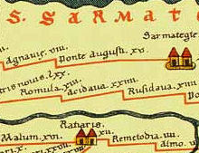
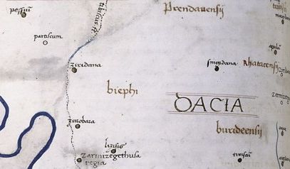
Ziridava is mentioned in Ptolemy's Geographia ( c. 140 ) in the form Ziridaua ( Ancient Greek : Ζιρίδαυα ) as an important town in western Dacia, at latitude 48° N and longitude 46° 30' E (he used a different meridian and some of his calculations were off). Ptolemy completed his work soon after Trajan's Dacian Wars, as a result of which parts of Dacia were incorporated into the Roman Empire as the new Dacia province. However, he based his work on older sources like Marinus of Tyre, as Ziridava is believed to have been destroyed during the war.
Unlike other Dacian towns mentioned by Ptolemy, Ziridava is missing from Tabula Peutingeriana (1st–4th centuries), an itinerarium showing the cursus publicus, the road network in the Roman Empire.
This prompted the Danish philologist and historian Gudmund Schütte to assume that Ziridava and Zurobara are one and the same. This idea is deemed erroneous alongside a number of other assumed duplications of names, by the Romanian historian and archaeologist Vasile Pârvan in his work Getica. Pârvan reviewed all localities mentioned in Ptolemy's Geographia, analyzing and verifying all data available to him at the time. He points out that Ziri and Zuro (meaning water ) are the roots of two different Geto - Dacian words. Additionally, Ptolemy provided different coordinates for the two towns, some medieval maps created based on his Geographia depict two distinct towns.
In the Dacian (North Thracian) language dava means city, town, fortress.
Vasile Pârvan considers that the form Ziri- is the same with a form Giri- (cf. Zermi and Germi). Ziri- corresponds to the Proto-Indo-European root ǵʰel- 'to shine, gold' so that Ziridava means " The gold fortress ".
Since no inscription have been found to date, Ziridava is hypothetically located at one of the following sites in Banat (western Romania ):
Based on his analysis of Ptolemy's Geographia and previously recorded data, Vasile Pârvan points out that Ptolemy had placed Ziridava in the extreme west of Dacia, near the middle Tisa River and identifies it, hypothetically, with the modern city of Cenad (Timiș), situated on the left bank of the Mureș, where Roman relics were found.
In 1868, in the middle of the old Cenad village, while digging the foundations of the new church, a variety of Roman objects were found, including bricks, a number of them stamped with Legio XIII Gemina (CIL, III, 1629, 1018, 8065), a sarcophagus fragment, a fragmentary stone inscription (CIL, III, 6272) and a denarius of Faustina. Later on, during various civil works, other Roman archaeological materials were discovered: weights, tiles, coins of the emperors Claudius Gothicus, Aurelian, Marcus Aurelius Probus and Constantius II, ceramic fragments, capitals of columns, brooches, etc. Until now no systematic excavations have been made within the village however. Based on material discovered accidentally at Cenadul Mare ( Big Cenad ), it is assumed that a Roman castra existed there, probably having the mission to supervise the transport on Mureş River. By contrast with the abundant Roman archaeological material, until date only a few Dacian pottery fragments were discovered accidentally and there is no information about the exact location of the findings. The fragments are preserved in the Museum of Banat in Timișoara.
A Geto-Dacian walled city dating to Burebista 's reign (82–44 BC) has been discovered at the archaeological site called ' Şanţul Mare ("Big Ditch"), 7 km from Pecica.
Archaeologist Ion Horaţiu Crişan was very involved with the research at Pecica and placed Ziridava at this location with a high degree of certainty. He wrote the book Ziridava – The Digs from "Șanțul Mare" From 1960, 1961, 1962, 1964, focused on the archaeological digs performed in the 1960s at this ancient city.
The site is a long-lived tell settlement of the Bronze Age. At least 16 archaeological horizons have been distinguished, starting with the Neolithic and ending with the Feudal Age (since the 12th century a cemetery existed in this place) and with one of the clearest sequence of pottery development in Banat. A large collection of stone molds for metallurgy was found, along with inhumation cemeteries containing rich grave goods of gold, bronze and faience and amber beads. The most important layers belong to the Bronze Age Pecica culture and the Dacian times.
Șanțul Mare is a mound located on the right bank of Mureş river, with an oval shape measuring 120 by 60–70 m. The long axis of the mound has a north-east-west orientation, being parallel with the course of the river. The mound is part of a fluvial terrace, which was separated by a huge moat surrounding it on all sides, with the exception of the east-south-east side. There, a steep slope is separating it from the terrace through which the Mureş flows today. Because of this unique location, the mound is heavily fortified, but it is not yet known whether it was naturally separated from the rest of the terrace by an older arm of the river or this type of fortification was done by people, artificially.
The earliest research at Şanţul Mare was done in 1870 by Iosif Hampel and Floris Romer from National Antiquities Museum, Budapest and proved the extraordinary importance of the tell. The amateur archaeologist Ladislau Dömötör, a painting professor at a high school in Arad, continued with digs in 1898–1900, 1901 and 1902, and the majority of known Dacian artifacts, until new excavations started in the 1960s, came from these efforts. The findings were numerous and significant, however the research was poorly documented and most of these materials have remained unpublished. The artifacts are kept at the Arad Museum Complex.
In 1910 a new campaign was started by the Cluj -based archaeologist Martin Roska, a pioneer of scientific archeology and the first that helped to clarify the chronological and cultural classification of the various horizons captured here. The excavations of 1910–1911, 1923 and 1924 identified a substantial dwelling of Middle Bronze Age with 16 horizons, the Mureş culture (originally called Periam-Pecica ). The reports reviewed mostly Bronze Age strata, but also that of the Middle Copper Age.
Dorin Popescu also probed the site in 1943, and after validating the chronological horizons identified by Roska, he drew attention to some remains of La Tène Period and Migration Period.
Despite multiple Dacian material findings, all previous campaigns focused on the Bronze Age. That, and the fact that previous research was amateurish or poorly documented, triggered new major excavations in the 1960s under the leadership of archaeologist Ion Horaţiu Crişan, together with Egon Dörner. The new excavations at Pecica have proved the existence on the fortified plateau of a large Dacian settlement with two different habitation horizons, as well as of a cemetery from 11th–13th century. The institutions that participated between 1960 and 1964 in research included the Institute of History and Archaeology, Cluj-Napoca, Arad Museum, Babeş-Bolyai University and the Institute of Medicine and Pharmacy, Cluj-Napoca.
More places to explore in Romania.