Greece
Lion Gate
City gate · Argos-Mykines Municipality
Archaeological site in Greece

Mycenae ( my-SEE-nee; Ancient Greek: Μυκῆναι or Μυκήνη, Mykē̂nai or Mykḗnē) is an archaeological site near Mykines in Argolis, north-eastern Peloponnese, Greece. It is located about 120 kilometres (75 miles) south-west of Athens; 11 kilometres (7 miles) north of Argos; and 48 kilometres (30 miles) south of Corinth. The site is 19 kilometres (12 miles) inland from the Saronic Gulf and built upon a hill rising 274 metres (899 feet) above sea level. In the second millennium BC, Mycenae was one of the major centres of Greek civilization—a military stronghold which dominated much of southern Greece, Crete, the Cyclades and parts of southwest Anatolia. The period of Greek history from about 1600 BC to about 1100 BC is called Mycenaean in reference to Mycenae. At its peak in 1350 BC, the citadel and lower town had a population of 30,000 and an area of 32 hectares (79 acres). The first correct identification of Mycenae in modern literature was in 1700, during a survey conducted by the Venetian engineer Francesco Vandeyk on behalf of Francesco Grimani, the Provveditore Generale of the Kingdom of the Morea. Vandeyk used Pausanias's description of the Lion Gate to identify the ruins of Mycenae...
The name Mukanai is thought not to be Greek but rather one of the many pre-Greek place names inherited by later Greek speakers. Legend has it that the name was connected to the Greek word mykēs (μύκης, "mushroom"). Thus Pausanias ascribes the name to the legendary founder, Perseus, who was said to have named it either after the cap ( mykēs ) of the sheath of his sword or after a mushroom he had plucked on the site. Homer connected the name to the nymph Mycene, the daughter of the river god Inachos of Argos ( Odyssey 2.120).
In the Iliad the name of the city is spelled Mykḗnē (Μυκήνη).
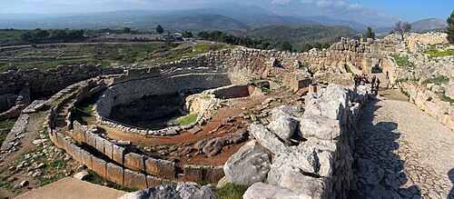
See also: Mycenaean Greece Mycenae, an acropolis site, was built on a hill 900 feet (274 metres) above sea level, some 19 kilometres (12 miles) inland from the Gulf of Argolis. Situated in the north-east corner of the Argive plain, it easily overlooked the whole area and was ideally positioned to be a centre of power, especially as it commanded all easy routes to the Isthmus of Corinth. Besides its strong defensive and strategic position, it had good farmland and an adequate water supply.
There are only faint traces of Neolithic settlement on the site although it was continuously occupied from the Early Neolithic (EN, c. 5000–c. 4000 BC). EN Rainbow Ware constitutes the earliest ceramic evidence discovered so far.
The Early Bronze Age (EBA) is known as the Early Helladic (EH) on mainland Greece, dated from around 3200-2050/2000 BC. The EH can be subdivided into EH I (3200-2650 BC), EH II (2650-2200 BC) and EH III (2200-2000 BC). Mycenae was occupied throughout this period.
Pottery material spanning the entire Early Helladic was discovered 1877 by Panagiotis Stamatakis at a low depth in the sixth shaft grave in Circle A. Further EH and MH material was found beneath the walls and floors of the palace, on the summit of the acropolis and outside the Lion Gate in the area of the ancient cemetery. An EH–MH settlement was discovered near a fresh-water well on top of the Kalkani hill south-west of the acropolis.
The Middle Bronze Age (MBA) is known as the Middle Helladic (MH) on mainland Greece, dated from around 2050/2000-1550 BC. At Mycenae the population grew considerably during the MH. In 1876, archeological digs conducted by Heinrich Schliemann found shaft grave evidence for extensive Cretan influence (Minoan) in the region from c. 1600 BC. Schliemann's shaft graves came to be known as Circle A to distinguish them from the Circle B graves, which were found at a later date, although Circle B are the earlier graves, dated c. 1650 BC to c. 1550 BC and entirely within MHIII. Circle A is dated to the sixteenth century BC, including the transition from Middle to Late Helladic IA (LHIA; c. 1550 – c. 1500 BC). The contents of Circle B are less wealthy than those of Circle A.
In MH II (c. 1800 BC), the first burials in pits or cist graves are found on the west slope of the acropolis, which was at least partially enclosed by the earliest circuit wall.
The Late Bronze Age (LBA) is known as the Late Helladic (LH) on mainland Greece, dated from around 1550-1200/1150 BC.
In the absence of documents and objects that can be precisely dated, events at Mycenae can be dated only relatively within the constraints of Helladic chronology, which relies on categorisation of stratified material objects, mainly pottery, within an agreed historical framework. Mycenae developed into a major power during LHI (c. 1550 – c. 1450 BC) and is believed to have become the main centre of Aegean civilisation through the fifteenth century to the extent that the two hundred years from c. 1400 BC to c. 1200 BC (encompassing LHIIIA and LHIIIB) are known as the Mycenaean Age. The Minoan hegemony ended c. 1450 and there is evidence that Knossos was occupied by Mycenaeans until it too was destroyed c. 1370 BC. From then on, Mycenaean expansion throughout the Aegean was unhindered until the massive disruption of society in the first half of the twelfth century (LHIIIC), which ended Mycenaean civilisation and culminated in the destruction of Mycenae itself c. 1150 BC.
Late Helladic I (LHI; c. 1550–c. 1450 BC)
Outside the partial circuit wall, Grave Circle B, named for its enclosing wall, contained ten cist graves in Middle Helladic style and several shaft graves, sunk more deeply, with interments resting in cists. Richer grave goods mark the burials as possibly regal. Mounds over the top contained broken drinking vessels and bones from a repast, testifying to a more than ordinary farewell. Stelae surmounted the mounds.
A walled enclosure, Grave Circle A, included six more shaft graves, with nine female, eight male, and two juvenile interments. Grave goods were more costly than in Circle B. The presence of engraved and inlaid swords and daggers, with spear points and arrowheads, leaves little doubt that warrior chieftains and their families were buried here. Some art objects obtained from the graves are the Silver Siege Rhyton, the Mask of Agamemnon, the Cup of Nestor and weapons both votive and practical. The chemical compositions of the silver objects indicate that the silver was sourced from several locations.
Late Helladic II (LHII; c. 1450–c. 1400 BC)
Alan Wace divided the nine tholos tombs of Mycenae into three groups of three, each based on architecture. His earliest – the Cyclopean Tomb, Epano Phournos, and the Tomb of Aegisthus – are dated to LHIIA.
Burial in tholoi is seen as replacing burial in shaft graves. The care taken to preserve the shaft graves testifies that they were by then part of the royal heritage, the tombs of the ancestral heroes. Being more visible, all the tholoi had been plundered either in antiquity or in later historic times.
Late Helladic III (LHIII; c. 1400–c. 1050 BC)
At a conventional date of 1350 BC, the fortifications on the acropolis and other surrounding hills were rebuilt in a style known as Cyclopean because the blocks of stone used were so massive that they were thought in later ages to be the work of the one-eyed giants known as the Cyclopes. Within these walls, much of which can still be seen, successive monumental palaces were built. The final palace, remains of which are currently visible on the acropolis of Mycenae, dates to the start of LHIIIA:2. Earlier palaces must have existed but they had been cleared away or built over.
The construction of palaces at that time with a similar architecture was general throughout southern Greece. They all featured a megaron, or throne room, with a raised central hearth under an opening in the roof, which was supported by four columns in a square around the hearth. A throne was placed against the center of a wall to the side of the hearth, allowing an unobstructed view of the ruler from the entrance. Frescos adorned the plaster walls and floor.
Closest places in our Greece guide.
More places to explore in Greece.